Blog
Editorials
Daily Editorials
Editorials In-Depth, 22 March
India State of Forest Report 2021
General Studies- III (Conservation, environmental pollution and degradation, environmental impact assessment)
BY Chrome Ias
Share
Trending
Latest Courses
Recently, the Environment, Forest and Climate Change ministry released the ‘India State of Forest Report (ISFR) 2021’.
India’s definition of forest:
As per India State of Forest Report, Forest cover is defined as:
“All lands, more than one hectare in area, with a tree canopy density of more than 10 percent irrespective of ownership and legal status. Such lands may not necessarily be a recorded forest area. lt also includes orchards, bamboo and Palm.”
About ISFR 2021:
- ISFR 2021 is prepared by the Forest Survey of India (FSI), which has been mandated to assess the forest and tree resources of the country.
- The ISFR-2021 provides information on forest cover, tree cover, mangrove cover, growing stock, carbon stock in India’s forests, forest fire monitoring, forest cover in tiger reserve areas, above ground estimates of biomass using SAR data & climate change hotspots in Indian forests.
Key findings:
- The total forest and tree cover of the country is 80.9 million hectare which is 24.62 percent of the geographical area of the country.
- As compared to the assessment of 2019, there is an increase of 2,261 sq km in the total forest and tree cover of the country.
- Out of this, the increase in the forest cover has been observed as 1,540 sq km and that in tree cover is 721 sq km.
- Increase in forest cover has been observed in open forest followed by very dense forest.
Area-wise Forest cover:
- Top three states showing increase in forest cover are Andhra Pradesh (647 sq km) followed by Telangana (632 sq km) and Odisha (537 sq km).
- Area-wise Madhya Pradesh has the largest forest cover in the country followed by Arunachal Pradesh, Chhattisgarh, Odisha and Maharashtra.
Percentage-wise Forest cover:
In terms of forest cover as percentage of total geographical area:
- The top five States are Mizoram (84.53%), Arunachal Pradesh (79.33%), Meghalaya (76.00%), Manipur (74.34%) and Nagaland (73.90%).
- 17 states/UT’s have above 33 percent of the geographical area under forest cover.
- Out of these states and UT’s, five states/UTs namely Lakshadweep, Mizoram, Andaman & Nicobar Islands, Arunachal Pradesh and Meghalaya have more than 75 percent forest cover.
- While 12 states/UTs namely Manipur, Nagaland, Tripura, Goa, Kerala, Sikkim, Uttarakhand, Chhattisgarh, Dadra & Nagar Haveli and Daman & Diu, Assam, Odisha, have forest cover between 33 percent to 75 percent.
Mangrove cover:
- Total mangrove cover in the country is 4,992 sq km.
- An increase of 17 sq Km in mangrove cover has been observed as compared to the previous assessment of 2019.
- Top three states showing mangrove cover increase are Odisha (8 sq km) followed by Maharashtra (4 sq km) and Karnataka (3 sq km).
Carbon stock:
- Total carbon stock in country’s forest is estimated to be 7,204 million tonnes.
- There an increase of 79.4 million tonnes in the carbon stock of country as compared to the last assessment of 2019.
- The annual increase in the carbon stock is 39.7 million tonnes.
Significant Features of ISFR 2021:
- In the present ISFR 2021, Forest Survey of India (FSI) has included a new chapter related to the assessment of forest cover in the Tiger Reserves, Corridors and Lion conservation area of India.
- For decadal assessment, change in forest cover, during the period between ISFR 2011 (data period 2008 to 2009) and the current cycle (ISFR 2021, data period 2019-2020) within each Tiger Reserves has been analysed.
- A new initiative of FSI has also been documented in the form of a chapter, where the ‘Above Ground Biomass’ has been estimated.
- FSI, in collaboration with Space Application Centre (SAC), ISRO, Ahmedabad, initiated a special study for estimation of Above Ground Biomass (AGB) at pan-India level, using L- band of Synthetic Aperture Radar (SAR) data.
- FSI in collaboration of with Birla Institute of Technology & Science (BITS) Pilani, Goa Campus has performed a study based on ‘Mapping of Climate Change Hotspots in Indian Forests’.
- The collaborative study was carried out with the objective to map the climatic hotspots over the forest cover in India, using computer model-based projection of temperature and rainfall data, for the three future time periods i.e. year 2030, 2050 and 2085.
- The report also contains information on various parameters State/UT wise.
- Special thematic information on forest cover such as hill, tribal districts, and north eastern region has also been given separately in the report.
Significance:
It is expected that the information given in the report would provide valuable information for policy, planning and sustainable management of forest and tree resources in the country.
Important facts:
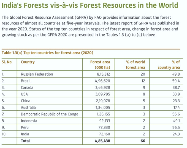
Forest resources in the word:
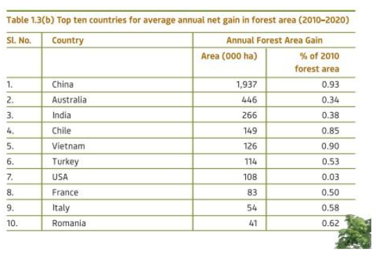
Average annual net gain in forest area:
Source: The Hindu / Down to Earth
BY Chrome Ias
Trending
Latest Courses
For Daily Updates
Sign up for daily emails to get the latest Chrome IAS news.